An incredible coincidence, 30 years apart

IDENTICAL SHOTS FOR AN INCREDIBLE SEARCH


On one Sunday of October 2015, the Prime Ministers of Peru and Italy were visiting Machu Picchu and Adine Gavazzi, together with José Bastante, José Bastante, the head of the Archaeological Park of Machu Picchu, was asked to accompany them on a helicopter flight to view the site. This was permitted because requested on behalf of Fernando Astete, as helicopters are usually forbidden from flying in Machu Picchu, as they tend to scare animals. The journey began and Adine vividly recalls how she got her camera ready and took a picture for every second that she was up in the air. According to Adine, she was trying to see if there was a visual connection between Mountain Machu Picchu and Salkantay, a big glacier to the south of the site.

The Machu Picchu mountain corresponds to the very last geological outpost of the glacier. In fact, it is geologically connected to Salkantay and the Inca knew that. Adine had wanted to verify this fact and also understand if the visual line that connects the tip of Machu Picchu to the tip of the Wayna Picchu was the same as the line that connects the Salkantay to Machu Picchu. It was only recently, however, that she made a connection between one of the images that she took that day and one that had been taken by Fernando Astete thirty years before. Adine was ecstatic.

“While I was going through Fernando’s pictures, incredibly I found the same picture, except for the fact that his was much better, because the day I took the picture it was clouded, so you couldn’t see the Salkantay. You could see the axis connecting Machu Picchu and Wayna Picchu but you couldn’t see the Salkantay. Fernando had taken exactly the same picture thirty years before, exactly in the same spot. And the most incredible thing is that, how can you do it when you’re on a helicopter? I didn’t even know Fernando had taken the picture. So there is something very special in the story of that photo. Thirty years later I got the exact same picture in the air with the helicopter. What’s amazing is that, there you can be ten meters right or left, or even up or down and the picture would turn out different. But I took exactly the same picture and it’s truly extraordinary.”

Adine believes that the most likely explanation to this coincidence was that they were both looking for the same thing, with their eyes looking in the same direction. Adine was able to pass through the same location that Fernando had traveled by with the helicopter thirty years back. What was even more astonishing is that they both inclined the camera to be able to see the exact flat surface of the open square. According to Adine, in order to be able to capture that scenery, one must incline the camera in a certain way. It is an incredible coincidence indeed.

This is something Adine would have never discovered if she had not gone through and classified Fernando’s photos for this project. This account becomes even more significant as it tells a story far deeper than just a mere coincidence. In fact, it shows Inca’s and Fernando’s way of looking at the mountains. He was looking for one of those visual lines that the Inca were observing when they would go on top of the mountains before planning a city, an urban area, or a Yakhta. The incredible thing is that this coincidence is proof that it still works like that to this day. It is an element of the living culture that still exists. Adine learnt it from the workers. Even though she had learnt about this process from chronicles, she could not understand it properly.


“The chronicles kind of knew that the incas would align the points but they didn’t know how; so they didn’t explain it very well. The workers in Machu Picchu do it every day so you kind of inherit this knowledge, and what we understood is the peculiar way in which the incas had to plan. They plan from the top, they look at things from the top. However, they don’t just look at things from one top, they go all around. So they went all around these eighteen mountains, went on top of each and every mountain, and they looked at the site where they would plan Machu Picchu. They kind of drew imaginary lines to connect orientations, and when they did all of that, they went to the highest top of the biggest stone, or the biggest emerging rock, and on the very top of that they carved the Intiwatana. And in the Intiwatana you had the exact orientation, miniaturizing the entire plan. If you understand this notion, you understand the Intiwatana.”
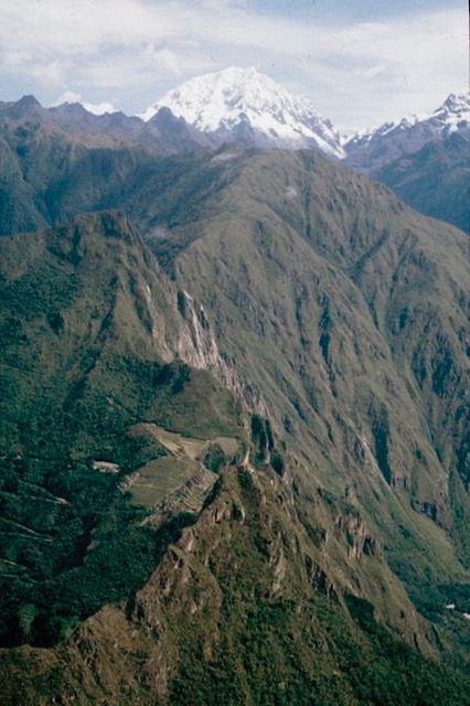
Image taken by Fernando Astete 30 years ago

The Intiwatana is an altar on top of an emerging rock, which was usually operated for solar observations. That was its use indeed, but there was also more to it. It is, in fact, a miniature plan of all the lines of the city. Therefore, if one is not sure where to look, the Intiwatana will help them understand the planning, with a fan that from the center of the stone radiates lines in many directions.

At the Intiwatana, there are also places where one can sit next to or in front of and be positioned exactly to see something. Like the top of the Machu Picchu or Wayna Picchu, you are able to see specific parts of the site.
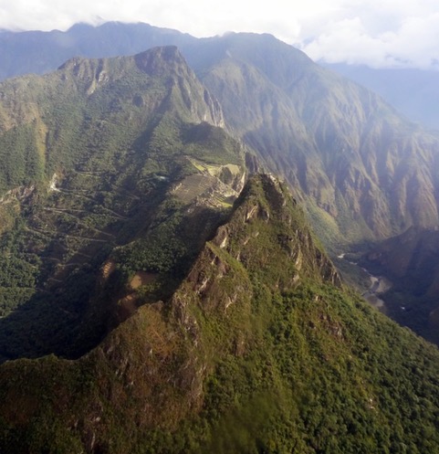
Image taken by Adine Gavazzi on October 2015
The route of the river

THE FLOW OF THE RIVER 


This river was channeled in Inca times and definitely left its mark. The path starts from Aqokqasa hill, and right above the road, the site of Tunasmoqo can be seen. 

This particular image is really interesting, as it clearly shows the original movement/route of the river. Over time, the river bed was moved by the Incas, so that they could use the remaining surface for blossoming vegetation and growing their food. The river bed was designed to create a special type of environment and to allow for the growth of plants, while also being able to design terraces. This can clearly be seen on the left side of this picture, which is truly significant as far as landscape planning goes. On the right side of the image, however, the terraces have different levels.

In order for viewers to better visualize the initial direction of the river, Adine explained: 

“You can see the river, which runs straight, but you also see, on both the right and left sides, a sort of curve. It’s as if you were looking at a bottle shape and the water was running in the middle. The round part of the water flow is an artificial modification made by the Incas. It is not natural. What is natural in the picture above is what is seen on the top of the frame. The river moves right-left, right-left, and then it goes right. It is kind of more disturbed. That is the river that was not modified. In fact, the rest is a landscape design, as the entire area was altered by the Incas.”


When asked about the possible reasons for all the modifications, Adine explained that there could not be a single answer. For example, why would the Inca make alterations to this particular area and not somewhere else? There are, in fact, a variety of reasons that lead to landscape design. First and foremost, the amount of surface available. Because this is a  mountainous environment, the optimal goal is to search for a flat surface. Therefore, whenever the Incas would find a flat surface, they would use it and if they could not find one, they would then create a new one. The main reason for this is that the Inca liked to have very flat terraces, and this is just because their way of modifying the environment had a very strong aesthetic value to them. According to Adine:

“They would never do something that was visually counter-intuitive or that would look strange to the eyes. This is why we don’t immediately see the modification of the landscape.” 

For someone from the Andean culture, or even just from Peru, modifications are easily distinguishable. However, for a Western individual, the change is not easy to point out, no matter how obvious. Using this picture by Fernando Astete as an example, Adine explained:

“Look how straight the river is at its lowest part, and the look at the upper part, notice how uneven the river is. So the upper part is natural whereas the lower part is modified. You know this because the behavior of the river is not naturally like that. However, it is not the natural flow of the river that’s changed, it’s somebody else who has altered it. In this case, the Inca.”

An Inca could notice modifications right away. Even today, a student from Cusco who’s never dived into this question could see it immediately. Even a little kid could show it, without even knowing the word landscape. 


Another interesting element detectable in this image is the paths created by those who lived in and traveled through the area.

“You see the river, and left to it you see a trail that kind of follows its path. In the lower part of the picture, you have the river first, the terraces, and then finally the trail. There is a space. When the terraces end, the trail gets closer to the river and moves up. The point where it gets kind narrower and closer to the river is on the left side, where you kind of see a zigzag line – That is not Inca. That is the modern trail.”

Adine further explained that no Inca would ever build a zigzag line unless there was no other space left. The reason behind this is that the Inca believed that one’s body had to be directed to what can be seen in front of them. If one moves their body too much to the sides, they can easily get dizzy or even become sick. The body had its own GPS and the Inca were aware of it.

Therefore, in order to experience Machu Picchu in its full authenticity, it is very important to follow the Inca trails as much as possible. Those trails have been planned not only to connect sites, but to also clearly show things that could possible go unnoticed. To walk on a pre-Hispanic trail of any kind, means walking on a landscape that has been designed prior to its opening. The connections are several and it is never random. In fact, there are paths created by the Inca for priests, militaries and other travelers, who were actually not allowed to go through their territories. Why? Adine answered:

“This is because you will see a landscape that you’re not trained to see. It’s like you’re a five year old taken to the Opera. You would not understand, it is too complex. So there are landscapes that have been designed to give you a specific perception of them or to connect you with what you see in a very special way. This is because images have the power to influence your mind and, of course, we have thousands of years of art production supporting this concept. Similarly, the sceneries are pieces of art, and therefore some paths and trails or walks are not for everybody. There is a hierarchy. For the Western mind that is very difficult to grasp, because to us, a path is a path, you just choose the most convenient way. We also only think about the functional aspect of conquering the mountains. To an Inca mind, however, this is completely incomprehensible, because you didn’t conquer nature, they honored it. In fact, they didn’t believe in conquering anybody or any place, they simply respect them.”


Conceiving Time and Space from and Andean Perspective

TIME AND SPACE ACCORDING TO THE ANDEAN PERSPECTIVE 


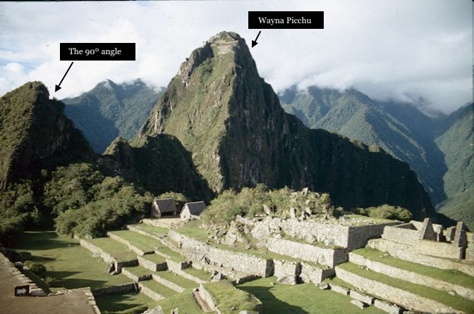
These images show the southern area of ​​the Ushnu. While today this part of the site presents a lot of vegetation, it is clear that this construction had not been completed by the Inca, as during excavations it lost much of its visibility.  

One of the images portrays the specific shadow relationship between the Huchuypicchu and Huaynapicchu. The big terrace seen in the image looks quite disordered, since the work on its construction was left unfinished. All these parts are usually covered by vegetation in most images of the Ushnu, which literally translates into “throne” and was a place where the Inca used to sit, do administrative work, and receive people. It was usually in the main square, but in this case, since there was no available space, it was put on the edge of the area. However, it still has a special connection to the Wanka, which was originally in the middle square, but cannot be seen today. A very interesting fact is that there is not a lot of vegetation surrounding it and that all the buildings of the Wayna Picchu are visible. In fact, this is because the image was taken right after an extensive fire.

Understanding the architecture of Machu Picchu means understanding its relevance to the sun and the shadows it creates over the buildings of the sanctuary. In this image, the Huchuy Picchu is shown, reflecting very low on the illuminated facade of the Wayna Picchu, meaning that the sun behind the Huchuy Picchu was lowering, but was still very high, as the shadow is not as high to cover most of the site’s facade. Therefore, the sunset was just about to begin in this picture. When asked if it would be possible to climb up the Wayna Picchu, Adine Gavazzi confirmed.

“Oh yes, there is a special time to go there. Very, very beautiful,very powerful, and very dangerous as well. Tourists are allowed to go, but a very reduced number of tourists, and they have to be visually controlled by the Hilantes, because in many parts, you can fall. If you fall from there, there is no possibility that you will survive the fall from the Wayna Picchu. More than three hundred people have died since we know Machu Picchu. Three hundred is a big number, I mean, Machu Picchu has been open to the public for only the last hundred years and we have three hundred people who died. That’s like three people each year. It’s scary. The most dangerous thing to do is hiking up the Wayna Picchu and so everybody wants to do that.”


Another interesting story that was told about this picture was the one regarding the significance of the little ninety degree angle that is visible at the top of the mountain next to Wayna Picch. It is not just an ordinary space, but a very special site, where indigenous people still get married. It is not something that many people are aware of and climbing that area is not possible, as it is not open to the public.

Now, is there a specific reason why? As a matter of facts, yes. That specific place at the top is one of the points where it is possible to see the areas where people were buried. According to Adine, Andean people believe that: “When you are looking at dead people, you are looking at your future and at your past as well.” Therefore, for them it is very important to have the opportunity to be looking at their ancestors. This is also one reason why deceased people are buried high up in the mountains, as looking down on them signifies looking higher to one’s future. Adine also explained that ancestors are considered those who are ahead of us, not behind us, because we are all heading towards where they already are. This is not a very easy concept for the Western mind to grasp.

“To understand how they conceive time and space, think of a procession with music. For instance, there is a festivity and there are musicians: the oldest ones go first with their instruments and the kids are at the end because kids follow older people. We walk in the footsteps of our grandparents, so time goes backwards. This is very difficult to grasp. It took me many many years to think like that. Because in our Western mind we go forward, our time has a beginning and we go forward. But then when you hear old sayings like ‘we walk in the footsteps of our grandfathers’ you realize our ancestors are literally those who are in front of us. So we also have a tiny winy memory of this ancestral way of thinking. This is why it is so important to make peace with your past. Because if you don’t make peace with your past, your path is wrong, it’s going to be broken, your life will not be happy…You have to make peace with your past, it’s literally compulsory. When you have a natural catastrophe, the first thing you do is you make peace with the event as if you don’t want to be quarreling with the forces of nature. So you make peace with the past. This is why this area for marriages and burials is located right over here.”


Moutain Yanantin and the skyline

MOUNTAIN YANANTIN AND ITS SKYLINE

Significance behind the images 


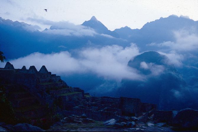
This image of mount Yanatin was taken in front of the site’s keep, probably sometime during August.

This specific skyline is very special and much appreciated all over the world. In fact, it is used in pictures anywhere, from advertising materials to mere websites, and so on. One interesting reason why it is so special is that all workers of Machu Picchu can tell the exact date that the picture was taken on, only by looking at the sky. By using the skyline, the workers can determine exactly the day and the year, as the sun goes along the skyline like a clock, between one limit to the other limit, almost “oscillating” from one side to the other.

Another reason why this picture is so unique is that the skyline is never straight. It has a hundred thousand very small points, making it very easy to measure the position of the rising sun. So whenever there are not any clouds, which is at least seventy to eighty percent of days in a year, all the workers can tell the date, which is determined only by looking at the area to the east.


This special skyline is also the reason why the majority of the windows in the sanctuary are facing east. Moreover, the time can be determined by looking at the lower part of the skyline. Thus, when looking at Wayna Picchu, a watch is not needed.

Comparing different pictures, it is possible to see how the mountains are projected on the skyline, thus in the morning the effect is reversed. The sun comes out from the skyline in the back and, in the afternoon, shadows can be visible. Looking at the west side gives exactly the same effect, but upside down. Therefore, the skyline literally is an astronomical theater at every moment of the day. Any skilled person can tell the day and the time, taking into consideration that this can be done almost everywhere with mountains. Andean people had this ability, which is still greatly used in the current Andean culture.


The First Aerial Image of the Saqsahuamán ever Taken

THE FIRST AERIAL IMAGE OF THE SAQSAHUAMÁN


Outstanding in the archaeological site are the bastions of Saqsqahuamán and the Suchuna area, connected through the central opening in space of the park.

This image of Saqsahuamán, taken by Fernando Astete, shows the trace of the city of Cusco at the top of the picture, right above the first mount, surrounded by a zigzag wall. This is the only part of the bastions that is usually considered and appreciated when publishing. However, Saqsahuamán is way bigger because the parts that can be seen at the bottom of the picture are also a part of it. The bigger round part at the bottom is known to be a public area, which originally served as a water reservoir and became a sacred artificial lake, made and used by the Incas. It was also used for water distribution around the city of Cusco.

This image, in fact, is a very important picture, not only because of what it shows, but also because of its significance.

For example, as Adine Gavazzi, a Swiss architect specialized in anthropology of the Andes and the Amazon, explained: 

“In the middle of the picture you have the open square, which is empty. This is exactly like what happens in Machu Picchu: an empty something in the middle, a mount with zigzags on one side, which is the Hanan area, the Hurin area on the other side, with zigzag walls representing the male area and the empty zones representing the female area.”


“It is so interesting because it is reproducing a sacred topography, with all the sacred elements you need to perform all the ceremonies, but it is not just the two mounts. It has been built up to have all these elements together, to have ceremonies.” 

Another fascinating fact is that this was literally the first picture to ever be taken of the site from the sky. Before this, nobody had ever taken pictures of the Saqsahuamán, comprising all areas. Thus it is the first complete aerial picture of this part of the site, which increases its overall historical significance and value.